August 5, 2020
Pilot Decision Making Focus of Fatal CFIT Accident Investigation
admincopa
TSB Report of 2019 Caravan Crash Released
A detailed investigation by the Transportation Safety Board into the August 6, 2019 crash of a Cessna 208B Grand Caravan into the end of a box canyon in the Yukon, leading to the death of the pilot and his passenger, revealed that the pilot did not follow company procedures in making decisions affecting his flights.
The occurrence aircraft was on a VFR flight itinerary that started at 08:30 in the morning at Mayo airport (CYMA) with the first flight to Rackla Strip. After returning to Mayo, the next flight planned was to Rau Strip. The first round trip was conducted without any issue, with post-crash analysis of GPS data showing flight altitudes of 7,500 and 8,500 feet above sea level (ASL), well above terrain peaks of 6,500 feet ASL. However, analysis of the data for the outbound flight from Mayo to Rau Strip revealed that the aircraft flew along parts of Granite Creek at 4,200 feet ASL, or 100 to 200 feet above ground level (AGL). Witnesses on the ground along Granite Creek reported seeing the aircraft flying at tree-top level in rain just below cloud bases.
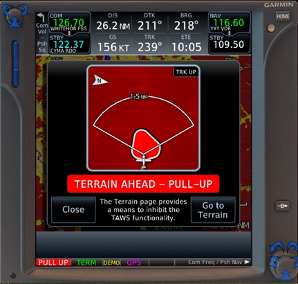
The return route was planned to be the reverse of the outbound route. Leaving Rau Strip 44 minutes after having landed there, the Caravan entered the Granite Creek portion at 156 knots and at an altitude of 4,300 feet ASL. Company procedures called for flying in low visibility conditions at 90 knots indicated airspeed with a flap setting of 20 degrees. Ground-based witnesses at a mining exploration camp along Granite Creek reported the aircraft was flying at tree-top level with low clouds at tree-top height ahead of it. At that point it was reported that the aircraft began to climb and disappeared in the clouds approximately one mile from the accident site.


Half a minute later the Caravan impacted terrain at high speed and the aircraft was destroyed. The 406-MHz ELT did not emit a signal (the antenna cable had become detached upon impact).
Alkan Air Ltd., operator of the flight, has introduced further accident prevention measures to avoid such an accident from reoccurring.
The full TSB report is appended below.
Top photo credit: TSB
a19w0105